
Page 119 - SST Class 06
P. 119
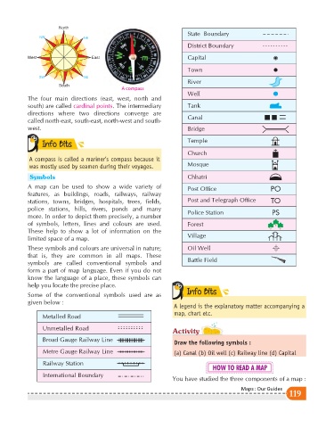
North
                                                                          State  Boundary
                NW                NE
                                                                          District Boundary


            West                     East                                 Capital
                                                                          Town
                SW                SE
                                                                          River
                        South
                                                A compass
                                                                          Well
            The four main directions (east, west, north and
            south) are called cardinal points . The intermediary          Tank
            directions where two directions converge are
                                                                          Canal
            called north-east, south-east, north-west and south-
            west.                                                         Bridge


                 Info Bits
                 Info Bits                                                Temple
                                                                          Church
            A compass is called a mariner’s compass because it
            was mostly used by seamen during their voyages.               Mosque
             Symbols                                                      Chhatri
            A map can be used to show a wide variety of                   Post Office                     PO
            features, as buildings, roads, railways, railway
            stations, towns, bridges, hospitals, trees, fields,           Post and Telegraph Office       TO
            police stations, hills, rivers, ponds and many                Police Station
            more. In order to depict them precisely, a number                                              PS
            of symbols, letters, lines and colours are used.              Forest
            These help to show a lot of information on the
                                                                          Village
            limited space of a map.
            These symbols and colours are universal in nature;            Oil Well
            that is, they are common in all maps. These
                                                                          Battle Field
            symbols are called conventional symbols and
            form a part of map language. Even if you do not
            know the language of a place, these symbols can
            help you locate the precise place.
                                                                          Info Bits
                                                                          Info Bits
            Some of the conventional symbols used are as
            given below :
                                                                     A legend is the explanatory matter accompanying a
                                                                     map, chart etc.
                  Metalled Road

                  Unmetalled Road
                                                                    Activity
                  Broad Gauge Railway Line
                                                                     Draw the following symbols :
                  Metre Gauge Railway Line                           (a) Canal (b) Oil well (c) Railway line (d) Capital

                  Railway Station
                                                                                    HOW TO READ A MAP
                  International Boundary
                                                                    You have studied the three components of a map :
                                                                                               Maps : Our Guides
                                                                                                                 119